Living among 13 rivers and flood canals, the residents of Jakarta are no strangers to the presence of water flowing through the city. This overflowing water, however, does not translate to water as an abundant resource, given the city’s long-standing battles with pollution. In the past, it was not unusual to find locals bathing and washing their clothes in rivers, but such a sight is now hard to imagine in Jakarta. Today, the city’s longest river, the Ciliwung, is often found covered by a layer of floating garbage. Jakartans rely on sources outside of the city, such as the Citarum River located upstream in West Java, for their piped water supply. But getting connected to the centralized water supply is in reality, an unaffordable and inaccessible option for the vast majority. According to Jakarta’s Drinking Water Service Regulatory Agency (BRPAM) 2015 report, approximately 68 percent of Jakarta’s residents have access to piped water while only 2% of the population’s homes are connected to the centralized sewage infrastructure. Jakarta’s inadequate supply and decentralized forms of water management have led to industries and residents turning to groundwater to meet their needs. With groundwater being the most affordable water source, this has led to the over-reliance on groundwater. The resulting exploitation is a significant contributor to land subsidence.
Over the last decade, Northern Jakarta has sunk by 2.5 meters, quickly gaining the reputation as the world’s fastest sinking city. Meanwhile, global sea level rise is projected to be 3-10 mm per year. These are two separate crises. Land subsidence, unlike global sea-level rise, is largely attributed to local anthropogenic activities such as groundwater exploitation and soil compaction caused by the construction of buildings. Instead of looking to address factors that accelerate Jakarta’s sinking, much of the official attention has been directed to sea-level rise induced by climate change, with the construction of the National Capital Integrated Coastal Development (NCICD) wall, a costly coastal embankment aiming to tackle the coastal flooding and the problem of the sinking capital. This raises questions about how much official attention is given to coastal floods as opposed to city floods in light of global climate change discourses. Including the water supply crisis in conversations around climate change in Jakarta would introduce more specific sociopolitical, historical, and economic complexities of the issues at hand.
Floods are a normalized occurrence during heavy rainfall, but the rate and frequency of flooding has been a cause of concern in recent years, as flooding is unpredictable beyond the monsoon season. In a video interview regarding the February 2020 flooding, Governor Anies Baswedan hammered at the explanation for the severity of the situation. He points out two types of floodwater sources: local water (air lokal) and non-local water (air kirim) that come from upstream rivers outside of the capital. Almost as if to defer blame, he presented the flooding situation in Jakarta as an unavoidable issue with factors beyond the city’s control. This sentiment is echoed by Indonesia’s Meteorology, Climatology and Geophysics Agency (BMKG), which blames the disastrous 2020 floods on “climate-change driven global warming” with the city’s unprecedented temperature rise resulting in record high rainfall of 377mm per day. But blaming climate change for Jakarta’s flooding crisis obscures a myriad of pre-existing sociopolitical factors. With more than 97% of Jakarta having been urbanized, large catchment areas such as open fields and shores of mangroves that would naturally absorb rain are no longer available to relieve overflowing rivers and canals during the monsoon season. The 2013 floods, in particular, were exacerbated by a breached canal embankment in Central Jakarta, due to much of the city’s infrastructure being “continually provisional and in progress.”
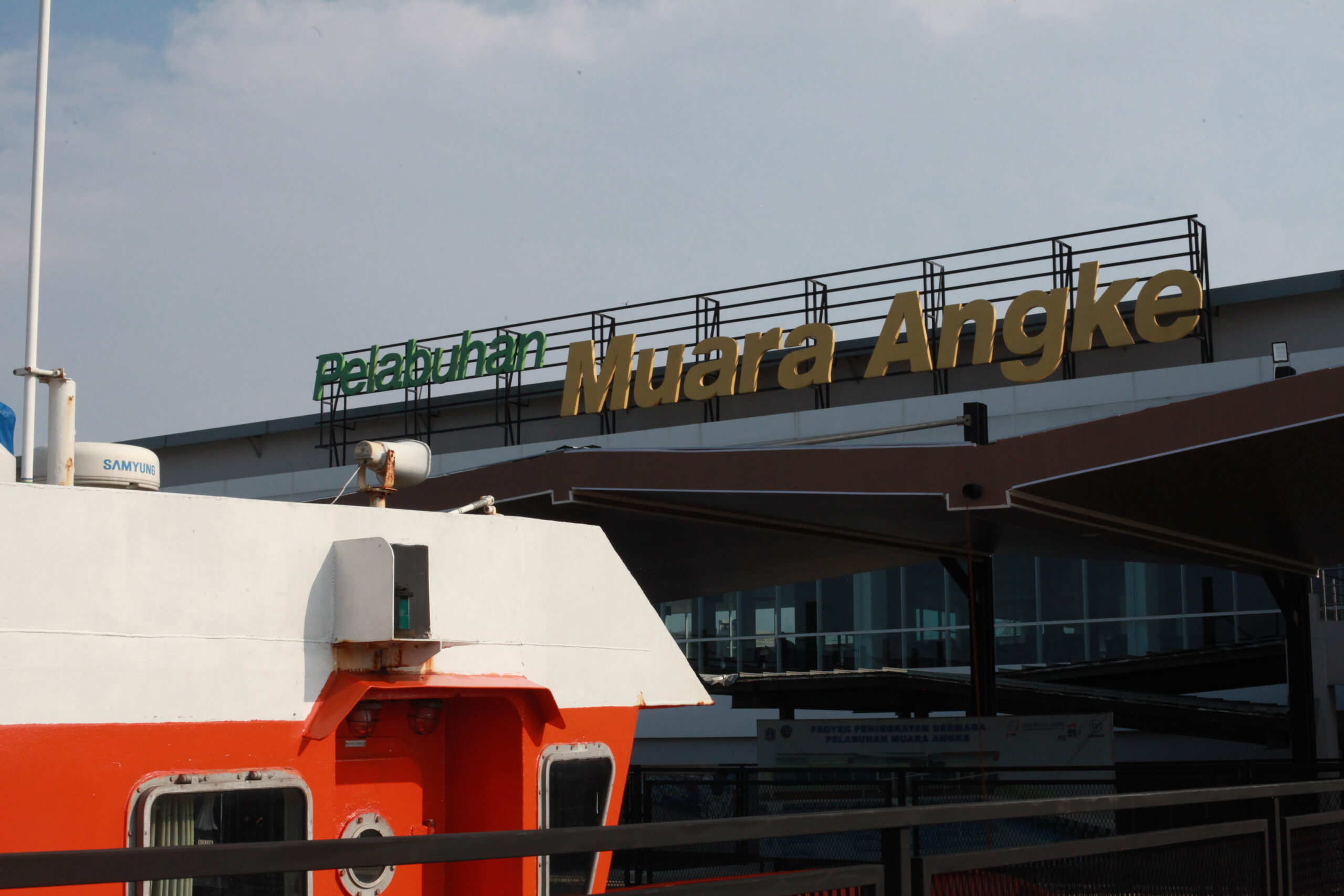
Muara Angke Harbor
Dewi Tan
With more than 40 percent of Jakarta already lying below sea level, scientists have been modeling projections of Jakarta’s coastal floods for the year 2050. The findings of the flood risk are concerning, with the rate of flood area expansion in the next 25 years projected to grow by 3.4 times that of what it has been for the past 25 years. Wary of climate reductionism, geographer Mike Hulme argues that attempting to predict climate-shaped futures downgrades human agency, because it doesn’t take into account how our environmental future is shaped socially, culturally, and politically. As conversations around Jakarta’s chronic sinking and flooding take the global stage in the face of climate change, it is concerning that the city’s problematic history of urban development and chronic water supply crisis gets rendered invisible on a local level. Climate change shouldn’t exempt the state from dealing with chronic waste management issues that plague existing polluted rivers, stripping their potential as valuable water resources. In other words, this localized water supply crisis should be underscored as an urgent issue to be addressed alongside climate change, which makes the city increasingly vulnerable to rising sea levels and chronic flooding.
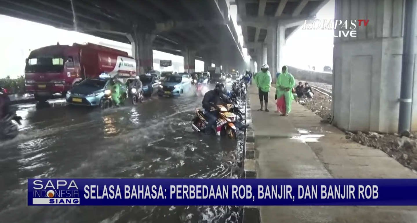
Screenshot from KompasTV’s YouTube channel
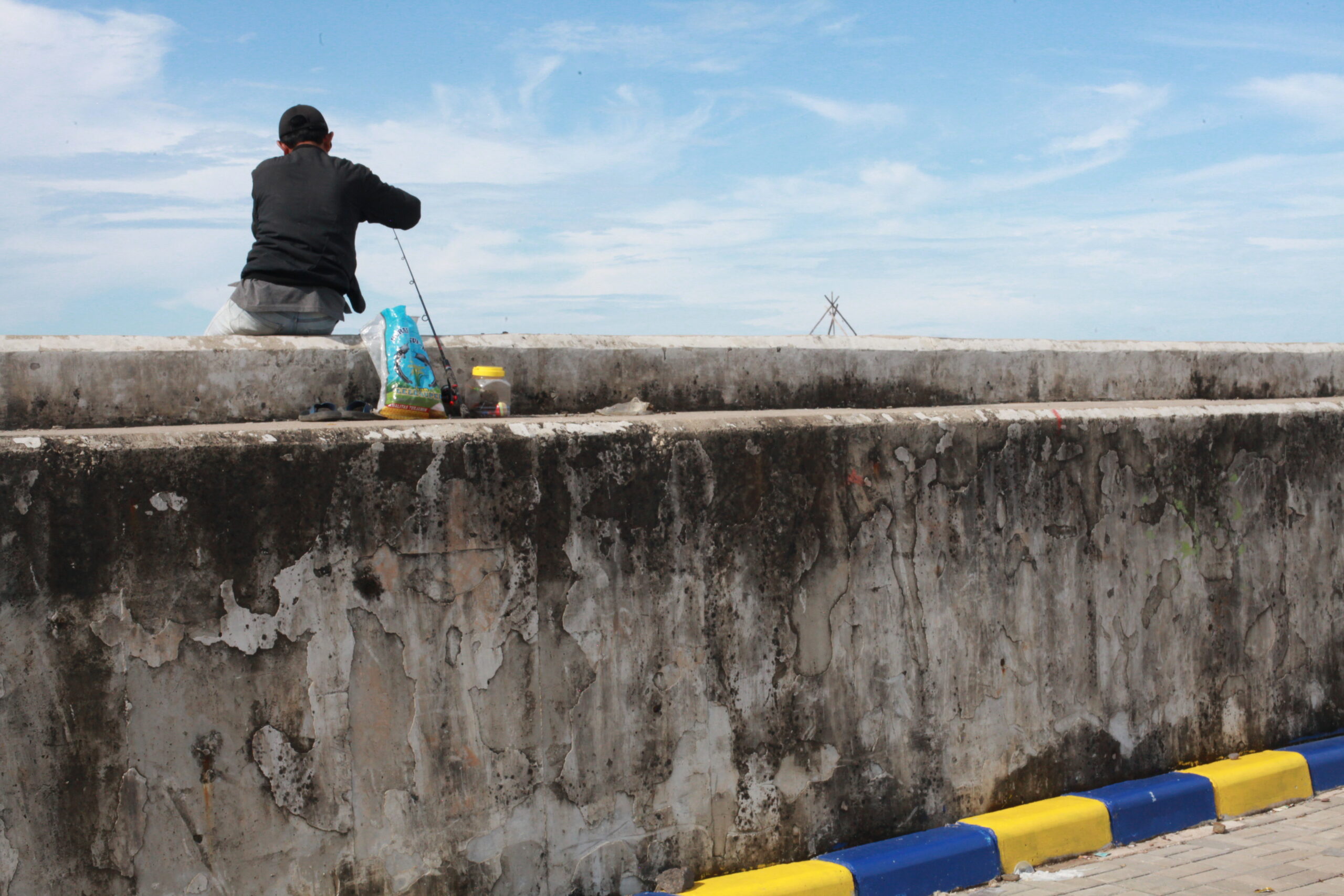
As climate change exacerbates Jakarta’s vulnerability to urban floods, scholars are mindful of how climate change is both a narrative and a material phenomenon — the lived experiences of locals and their perspectives, values, and knowledge can help us to understand the full meanings and impacts of climate change. In the case of Jakarta, it would be inaccurate to assume that the impacts of climate change, such as rising sea levels, would affect populations of various geographical regions equally. The question is how climate change translates from a global scale to a local one, and how local environmental crises compound its effects on already vulnerable communities. Fishing communities such as Muara Angke and Pejaringan in North Jakarta, for instance, face the highest risk of coastal floods given their proximity to the sea. Moreover, the building of a giant seawall along the coast invariably impacts their livelihoods given their dependence on direct access to the sea. Those living further inland in Jakarta are more concerned about the city’s inability to mitigate the effects of heavy rainfall, particularly along the roads that are crucial commuter routes.
In Jakarta, flooding and climate change are not strictly synonymous. There are three distinct types of flooding experienced in the city: 1) rob (tidal floods), 2) banjir (rain floods), and 3) rob banjir (rain and coastal flooding). Local news channel KompasTV explains in a 3-minute YouTube video how words such as rob and banjir, which both translate to floods in English, have different meanings to describe how water inundated the land. The educator in the video points out that the term rob refers to the rise of sea water onto the land due to tidal conditions, causing coastal flooding. Banjir connotes the overflow of water due to heavy rainfall, which causes water bodies such as rivers and canals in cities to flood. Lastly, rob banjir refers to a combination of tidal rise and heavy rain that causes sea water flooding. One interviewee even went on to express how these floods are “bencana alam dari laut” — natural disasters caused by the sea. Quick street interviews were conducted with locals to see if they could explain the differences between various flood terms. Ironically, all citizens interviewed expressed how “regular” or “normal” floods (banjir biasa) are, and that urban floods caused by heavy rainfall are at the fault of society, given the problems of congestion and poorly maintained canals.
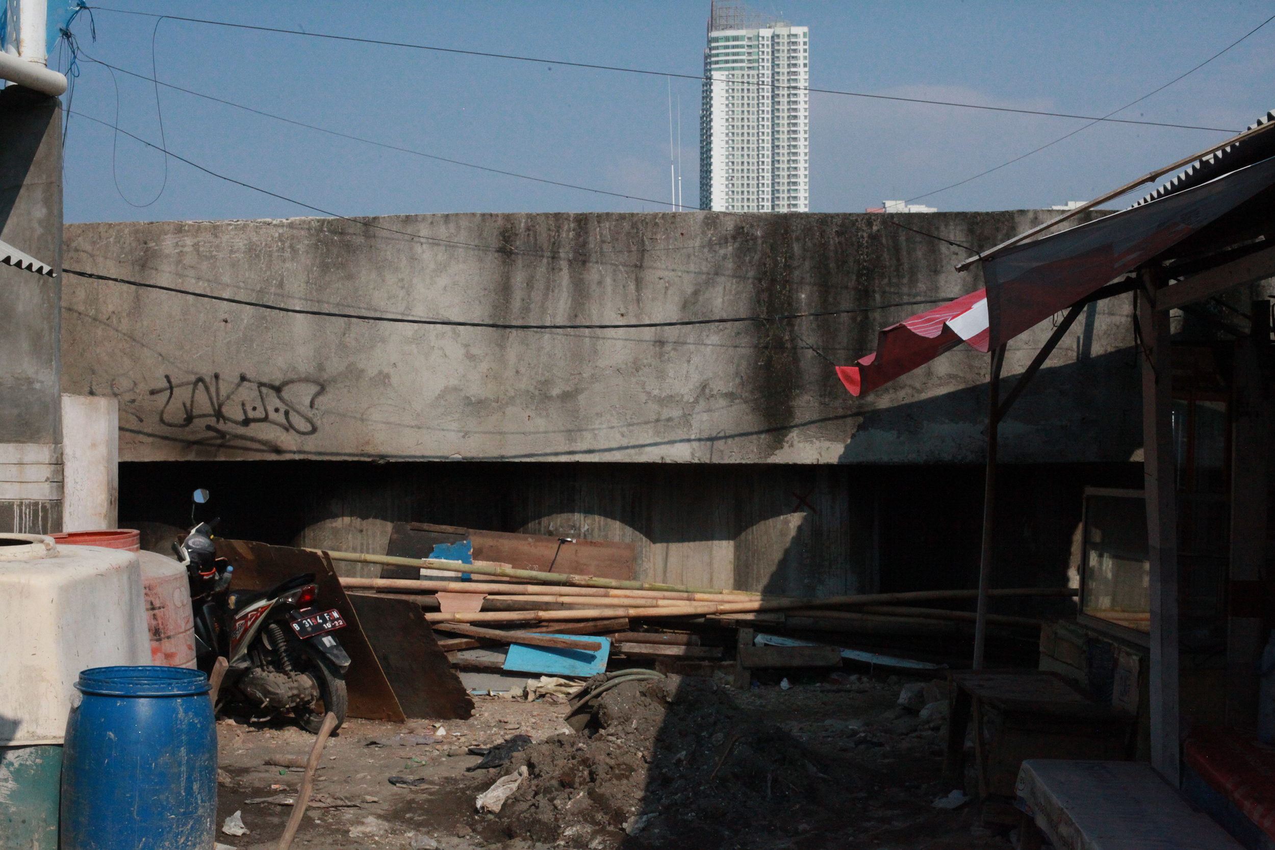
Seawall sandwiched between a kampung house and a high-rise condominium in Muara Baru
Dewi Tan
Ultimately, climate change impacts from global warming are contributors to, rather than the sole cause of urban flooding. Even if global warming was not a current threat, urban flooding would arguably still occur in Jakarta due to the city’s failure to mitigate the effects of heavy rainfall. Projections of Jakarta’s flood risk cannot be disentangled from land subsidence issues as it remains the predominant driver that leads to the exacerbation of coastal floods. Media representations of Jakarta’s sinking crisis need to be careful with narratives that could allow state officials to use climate change as a convenient — and global — scapegoat for the capital’s chronic urban flooding. Using Jakarta’s doomsday narrative also enables the state to justify the planned capital relocation to Kalimantan while doing little to remedy the environmental problems at hand. A key to tackling Jakarta’s sinking threat is to deepen our understanding of the relationship between water as a resource and water as a hazard. What is the relationship between the city’s water supply to urban floods, and how does excessive groundwater extraction impact land subsidence and subsequently urban flooding? It is essential to differentiate the impacts of inadequate water supply — the over-extraction of groundwater and subsequent land subsidence — from the climate change threats of rising sea levels and increased rainfall that make the city more vulnerable to urban floods. As we question the impacts of climate change on Jakarta, we also need to acknowledge how Jakarta’s chronic water supply crisis is responsible for the ecological degradation of the city.